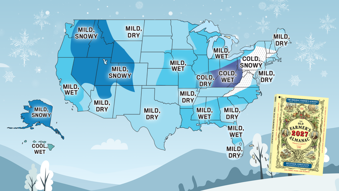
What will winter 2026–2027 bring where you live? See The Old Farmer’s Almanac Winter Forecast for temperatures, snowfall, and the snowiest periods across the United States.
Mostly Mild Winter — Colder, Snowier Spots Ahead!
- Temperatures: Mostly mild, with a colder stretch from central New England through the Appalachians and Ohio Valley, plus Hawaii.
- Wet/Dry: Wetter than normal across much of the West and in parts of the South, Midwest, and Florida; drier than normal in parts of the East, Plains, and Southwest.
- Snowfall: Snowier in parts of the Northeast and Appalachians, parts of the West, and Alaska.

Where Will It Be Cold This Winter?
A milder winter doesn’t mean the cold is taking the year off. Across much of the country, temperatures are expected to be near normal or warmer than normal. But colder-than-usual temperatures are expected from central New England south through the Appalachians and into the Ohio Valley. Hawaii will also be cooler than normal.
And remember: “Above normal” is relative. While it won’t be as cold as usual, it’s still winter!
Where Will It Be Snowy This Winter?
Love snow? You may be in luck. A snowier-than-normal winter is expected from central New England through the Appalachians, in the Intermountain region and Pacific Northwest, and in Alaska.
“Winter won’t look the same everywhere this year. While much of the country is headed for a milder season, some areas will still see plenty of cold and snow. Check the forecast for your region to see what’s ahead.”
Find Your 2026–2027 Winter Forecast
Not sure of your region? Find yours here.
Jump to a region:
1. Northeast 2. Atlantic Corridor 3. Appalachians 4. Southeast 5. Florida 6. Lower Lakes 7. Ohio Valley 8. Deep South 9. Upper Midwest 10. Heartland 11. Texas–Oklahoma 12. High Plains 13. Intermountain Region 14. Desert Southwest 15. Pacific Northwest 16. Pacific Southwest 17. Alaska 18. Hawaii
1. Northeast
The southern part of the Northeast will experience a more difficult winter, with below-normal temperatures and above-normal snowfall.
- Temperatures: Above normal in the north; below normal in the south
- Coldest periods: Early and mid-January
- Precipitation: Below normal
- Snowfall: Below normal in the north; above normal in the south
- Snowiest periods: Mid- and late December, mid-January, and early and late March
2. Atlantic Corridor
A milder winter is in store for the Atlantic Corridor, with above-normal temperatures and slightly below-normal snowfall.
- Temperatures: Above normal
- Coldest periods: Early to mid-December, early to mid-January, and early and late February
- Precipitation: Below normal
- Snowfall: Slightly below normal
- Snowiest periods: Late November, early and mid-January, early and late February, and late March
3. Appalachians
Winter will be tough in the Appalachians, with colder and snowier conditions, especially in the north. Overall, precipitation will be below normal.
- Temperatures: Below normal
- Coldest periods: Mid-January and mid- to late February
- Precipitation: Below normal
- Snowfall: Above normal, especially in the north
- Snowiest periods: Mid-January and early and late February
4. Southeast
Southern parts of the Southeast will have a milder, drier winter, with above-normal temperatures.
- Temperatures: Above normal
- Coldest periods: Mid-November, early and mid-December, early January, and late February
- Precipitation: Above normal in the north; below normal in the south
- Snowfall: Normal
- Snowiest periods: In the north, early January and late February
5. Florida
A milder winter is on tap for Florida, especially in the latter stages, while southern areas will see less rain overall.
- Temperatures: Above normal
- Coldest periods: Early and mid-December and early January
- Rainfall: Above normal in the north; below normal in the south
6. Lower Lakes
Despite being warmer than normal and less snowy, Lower Lakes conditions will still prove difficult, with above-normal precipitation and a classic winter January.
- Temperatures: Above normal
- Coldest periods: Early January and early February
- Precipitation: Above normal
- Snowfall: Near to below normal
- Snowiest periods: Early and late January and early February
7. Ohio Valley
Expect colder temperatures in the Ohio Valley, with a wetter eastern area and a number of snowy periods throughout the season.
- Temperatures: Below normal
- Coldest periods: Mid- and late January
- Precipitation: Above normal in the east; below normal in the west
- Snowfall: Slightly below normal
- Snowiest periods: Mid- and late January, mid-February, and early March
8. Deep South
Warmer-than-normal temperatures are on tap for the Deep South, with a few chances of snow in the north and wetter conditions to the south.
- Temperatures: Above normal
- Coldest periods: Mid-December, early January, and early February
- Precipitation: Below normal in the north; above normal in the south
- Snowfall: Below normal
- Greatest chance for snow: In the north, early January and early and mid-February
9. Upper Midwest
Expect milder months in the Upper Midwest to transition to colder-than-normal temperatures as winter continues. While snow will be near to below normal, there are many chances for flakes to fly in the new year.
- Temperatures: Above normal
- Coldest period: Mid- to late January
- Precipitation: Above normal in the east; below normal in the west
- Snowfall: Near to below normal
- Snowiest periods: Early and late January, late February, and early March
10. Heartland
The Heartland will be warmer and wetter overall, with near- to below-normal snowfall.
- Temperatures: Above normal
- Coldest periods: Early and late January and early March
- Precipitation: Above normal
- Snowfall: Near to below normal
- Snowiest periods: Early December, late January, and early March
11. Texas–Oklahoma
A warmer, drier winter is expected in the Texas–Oklahoma region. There is a chance for snow in the new year, so keep an eye on the forecast!
- Temperatures: Above normal
- Coldest periods: Early and late January and early February
- Precipitation: Below normal
- Snowfall: Near normal
- Greatest chances for snow: In the north, early and late January and early February
12. High Plains
Warmer and drier conditions are expected in the High Plains, along with below-normal snowfall.
- Temperatures: Above normal
- Coldest periods: Early and late January and early and late February
- Precipitation: Below normal
- Snowfall: Below normal
- Snowiest periods: Late January and mid-March
13. Intermountain Region
A warmer and wetter winter is forecast for the Intermountain region, while snowfall is also expected to be above normal and could make for tricky travel at times.
- Temperatures: Above normal
- Coldest periods: Mid- to late December, early and late January, and early February
- Precipitation: Above normal
- Snowfall: Above normal
- Snowiest periods: Late November, late December, and early February
14. Desert Southwest
Expect a mild winter in the Desert Southwest, with warmer and drier conditions, including in areas that usually receive snow.
- Temperatures: Above normal
- Coldest periods: Early and late January and early February
- Precipitation: Below normal
- Snowfall: Below normal in areas that usually receive snow
- Snowiest periods: Early January and late February
15. Pacific Northwest
Expect above-normal temperatures in the Pacific Northwest and, to no one’s surprise, a wet winter with above-normal snowfall.
- Temperatures: Above normal
- Coldest periods: Late December, early January, and early February
- Precipitation: Above normal
- Snowfall: Above normal
- Snowiest periods: Late December, mid-January, and mid-February
16. Pacific Southwest
The Pacific Southwest will be warmer and wetter overall. Mountain areas that see snow will have plenty of chances for it, especially in the new year.
- Temperatures: Above normal
- Coldest periods: Late December, mid- to late January, early February, and late March
- Precipitation: Above normal
- Snowfall: Near to above normal in mountain areas
- Stormiest periods: Late December, mid-January, early and late February, and early and late March
17. Alaska
While it will still be cold in Alaska this winter, temperatures will be above normal overall, with more snow compared with average. Precipitation will be above normal in the north but below normal in the south.
- Temperatures: Above normal
- Coldest periods: Late December, mid-January, and mid-February
- Precipitation: Above normal in the north; below normal in the south
- Snowfall: Above normal
- Snowiest periods: Mid-November, early and late January, mid-February, and late March
18. Hawaii
Hawaii will experience cooler-than-normal temperatures, but not dramatically so. Rainfall will be above normal, especially in the east later in the winter.
- Temperatures: Below normal
- Coldest periods: Early to mid-November, early December, late January through early February, and early March
- Rainfall: Above normal
- Stormiest periods: Mid-December and mid-January, as well as late February and much of March in the east

Get the Full Year of Weather Forecasts
You’ve seen the winter highlights. The 2027 Old Farmer’s Almanac includes our complete 12-month long-range weather forecast for the year ahead.
Prefer to buy locally? Find The Old Farmer’s Almanac in a store near you.
What’s Shaping Winter 2026–2027?
Long before the leaves turn, the clues are already appearing—in ocean temperatures, high-altitude winds, and the Sun’s own cycles. Here are the signals behind our winter outlook.
El Niño Has Returned
A strong El Niño has returned and is expected to continue through winter.
Last winter’s La Niña faded to neutral conditions, and El Niño returned during the summer. This year’s El Niño is expected to be strong, with unusually warm waters across the equatorial Pacific.
Think of the Pacific Ocean as one of Earth’s most powerful weather engines. During El Niño, those warmer waters can shift the jet stream—the fast-moving river of air that steers storms—and influence where rain, snow, and colder air travel across North America.
Strong El Niño winters often favor milder temperatures across much of the United States and wetter conditions in parts of the West and South. Those tendencies are also reflected in parts of our 2026–2027 forecast, but El Niño is only one piece of the winter puzzle.
Solar Activity Is Waning
Solar Cycle 25 is past its peak, and solar activity is waning.
Historically, high levels of solar activity have been associated with warmer temperatures on average—though that relationship has become weaker over time.
We’re Watching the Oceans and the Winds Above Us
The Atlantic’s warm pattern is expected to continue, while the Pacific’s cool pattern should weaken.
These slow-moving ocean patterns can influence the larger weather setup across North America.
We’re also watching a regular shift in winds high above the equator, known as the Quasi-Biennial Oscillation (QBO), as another piece of the winter picture.
What About the Polar Vortex?
If the polar vortex shifts south, it could send colder-than-average air from Canada farther into the United States.
The polar vortex isn’t a storm—it’s a large swirling pool of very cold Arctic air that usually stays near the North Pole in winter. Some or all of the factors above may cause it to shift southward this winter.
The Indian Ocean May Also Play a Part
A pattern in the Indian Ocean could strengthen the Pacific jet stream and increase storms in parts of the country this winter.
We’re monitoring sea-surface temperatures in the Indian Ocean for a pattern known as the Indian Ocean Dipole (IOD). A neutral-to-positive IOD could help produce that stronger jet stream.
Looking at the Whole Picture
No single climate signal determines what winter will bring. Long-range forecasting draws on these influences taken together—and at The Old Farmer’s Almanac, that blend of science and experience helps guide our winter outlook each year.
How Does The Old Farmer’s Almanac Predict the Weather?
The Old Farmer’s Almanac has been predicting the weather since 1792. Our long-range forecasts are based on a unique formula that combines solar science, climatology, and meteorology, along with historical weather patterns, current solar activity, climate data, and large-scale climate signals.
Learn how The Old Farmer’s Almanac predicts the weather →
Get The 2027 Old Farmer’s Almanac
Weather is only the beginning. For 235 years, The Old Farmer’s Almanac has mixed practical advice with the unexpected. The 2027 edition includes our complete 12-month long-range weather forecast, plus everything from medicinal plants and true BBQ to Mars, goats, surprising saints, gardening, astronomy, and more.
Find The Old Farmer’s Almanac in a store near you, or order online from Amazon, Barnes & Noble, or Walmart.

More Like This


Comments