
The 2026 Old Farmer’s Almanac Canadian Edition has arrived, bringing a season full of time-tested wisdom, long-range insight, and a dash of good humor. This winter’s forecast? Mostly wet and mild, but Canadians should still brace for snowy stretches, chilly snaps, and the occasional polar surprise.
Now available wherever books and magazines are sold, the 2026 Almanac Canadian Edition delivers more than weather—it’s your trusted companion for winter prep and year-round living.
Order your copy on Amazon.ca or find it at a local bookstore.
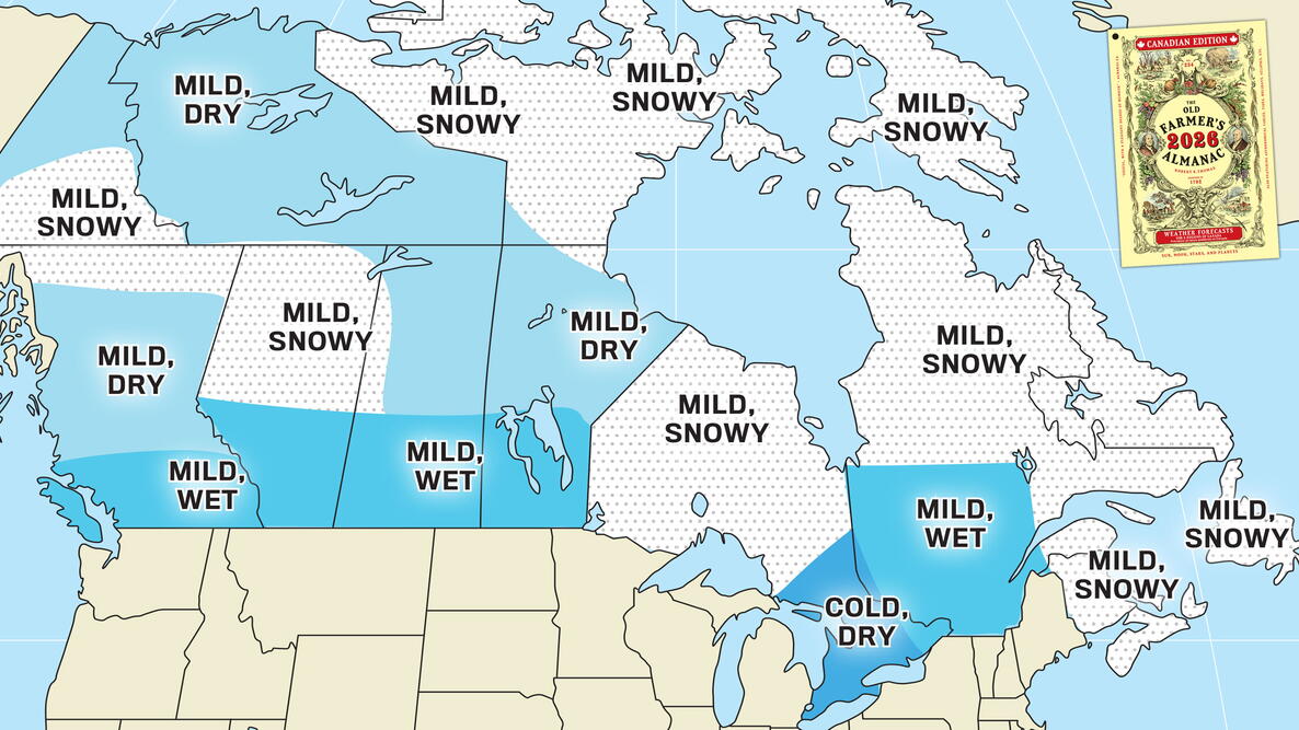
The season’s snow, cold, and precipitation are all mapped out on this page, giving you a clear look at what to expect from coast to coast.
The 2026 Long-Range Predictions for Canada
A Wet & Mild Winter!
Winter 2026 promises a season of contrasts. While much of Canada will see milder-than-average temperatures and frequent precipitation, some regions will still experience classic Canadian snowfalls and cold snaps. Here’s the big-picture outlook:
- Mild Temperatures: Winter will be milder than average across most of Canada, though southeastern Ontario may experience below-normal temperatures. Remember, “mild” is relative—plan and dress accordingly.
- A Wet Winter: Above-normal precipitation is expected from Atlantic Canada through Nunavut, southern Quebec and western Ontario, the southern Prairies, southern Yukon, and extreme southern British Columbia. Other regions should expect near- to below-normal precipitation.
- Snowfall: Above-normal snow is forecast from Atlantic Canada through northern Quebec and Nunavut, western Ontario, and the northwestern Prairies into southern Yukon.
- Mixed Weather: In areas like southern Quebec, precipitation will be above normal—but much of it may fall as rain or mixed events, keeping snow totals lower than usual.
Bottom line: Even a “mild” Canadian winter brings snowy stretches and cold snaps. Layer up, plan ahead, and keep your shovel handy!

Peek Inside the 2026 Almanac
The 2026 Old Farmer’s Almanac Canadian Edition delivers more than weather. Inside, readers will discover:
- How Canada’s immigrant communities shaped its gardens and cuisine
- The geology behind pingos—conical ice-cored hills with a hidden past
- Practical advice on soil conservation and sustainable farming
- Favorite Almanac features: folk remedies, Moon lore, and seasonal recipes
Order The 2026 Old Farmer’s Almanac Canadian Edition from Amazon.ca or support your local bookstore! See which stores carry the 2026 edition near you.
Atlantic Canada (Region 1)
including Halifax, Saint John, St. John’s
- Temperatures: Above normal
- Coldest periods: Early and mid-December, much of January
- Precipitation: Above normal
- Snowfall: Above normal; snowiest periods in mid-November, mid- and late December, early to mid-January

Southern Quebec (Region 2)
including Montreal, Ottawa, Quebec
- Temperatures: Above average (warmer than normal)
- Coldest periods: December, early and late January
- Precipitation: Above normal, with below-normal snowfall
- Snowfall: Below normal; snowiest times in late November, early and late December, early January

Southern Ontario (Region 3)
including Sudbury, Thunder Bay, Toronto
- Temperatures: Below normal in the east, above normal west
- Coldest periods: Mid- and late December, early and late January, early February
- Precipitation: Below normal east, above normal in the west
- Snowfall: Below normal in the east, above normal west; snowiest periods in late November, early and mid-February.

Southern Prairies (Region 4)
including Calgary, Edmonton, Regina, Winnipeg
- Temperatures: Above normal
- Coldest periods: Late November, early December, early February
- Precipitation: Above normal
- Snowfall: Below normal; snowiest stretches in late November, early December

Southern British Columbia (Region 5)
including Cranbrook, Prince George, Vancouver
- Temperatures: Above normal
- Coldest periods: Late November, early December, early February
- Precipitation: Below normal in the north, above normal south
- Snowfall: Below normal; snowiest periods in late November, early and mid-December

While not one of the most populous territories, the Almanac also predicts winter weather for the Yukon and NWT regions:
Yukon (Region 6)
including Whitehorse
- Temperatures: Above normal
- Coldest periods: Late November, early to mid-December
- Precipitation: Below normal in the north, above normal south
- Snowfall: Below normal in the north, above normal south; snowiest stretches in late November, late December, early February
Northwest Territories (Region 7)
including Yellowknife
- Temperatures: Above normal
- Coldest periods: Late November, early and late December
- Precipitation: Below normal
- Snowfall: Below normal; snowiest periods in late December and March
Piece by piece, the 2025–2026 Canadian winter outlook is coming into focus. With more regions yet to be revealed, the full wintry puzzle will be complete when The 2026 Old Farmer’s Almanac Canadian Edition arrives next week. Inside, you’ll find the entire season’s forecast—plus gardening tips, folklore, and timeless wisdom you can’t find anywhere else.
About The Old Farmer’s Almanac Long-Range Predictions
Since 1792, The Old Farmer’s Almanac has been forecasting the weather, blending time-tested tradition with modern science. Our long-range outlooks highlight seasonal patterns rather than daily conditions, examining climate signals and solar activity to predict whether the months ahead are likely to be colder, warmer, wetter, or snowier than average.
These forecasts are especially valuable for planners—from gardeners and farmers to shippers, travelers, and everyday Canadians preparing for the season.
The Canadian Weather Regions
The 2026 Canadian Almanac will feature detailed monthly forecasts for:
- Region 1: Atlantic Canada
- Region 2: Southern Quebec
- Region 3: Southern Ontario
- Region 4: Southern Prairies (Alberta, Saskatchewan, Manitoba)
- Region 5: Southern British Columbia
- Region 6: Yukon (digital edition only)
- Region 7: Northwest Territories (digital edition only)
Each forecast covers November through March, providing a big-picture view of temperatures, precipitation, and notable seasonal events—from cold snaps to snowstorms.

What Factors Are Shaping the Winter Ahead?
Several large-scale climate indicators and atmospheric conditions are already influencing what kind of winter Canada may experience. Here’s what we’re watching:
- Solar Cycle 25 recently peaked.
This current solar cycle has already outpaced the strength of Solar Cycle 24. While solar activity has historically shown some correlation with global temperatures, the relationship has become more subtle over time.

- La Niña has transitioned to neutral.
The shift from a weak La Niña to neutral conditions can influence jet stream patterns, affecting how cold air and storms move across Canada. - Ocean oscillations are steady.
The Atlantic Multidecadal Oscillation remains in a warm phase, and the Pacific Decadal Oscillation continues in its cool phase—both of which influence long-term weather patterns. - Stratospheric winds are a factor.
We’re monitoring the Quasi-Biennial Oscillation (QBO)—a high-altitude wind pattern near the equator—which can impact how Arctic air moves and whether it dips farther south. - The polar vortex may shift southward.
If certain conditions align, the polar vortex could be displaced, sending Arctic air deep into Canada and triggering periods of extreme cold and increased snowfall.
Together, these patterns act like winter’s control panel—steering the season’s behavior across provinces and territories. While nothing is set in stone, these signals help shape our forecast models.
How We Make Our Forecasts
At The Old Farmer’s Almanac, our weather forecasts are created using a blend of three scientific methods refined over centuries:
- Solar Science: Tracking sunspot cycles and solar output.
- Climatology: Analyzing long-term climate trends and historical weather data.
- Meteorology: Integrating modern atmospheric models.
By comparing current solar and climate conditions with historical weather patterns, we can predict the most likely seasonal outcomes. Our forecasts reflect climate normals over decades, not just year-over-year comparisons.
Unlike short-term weather forecasts, which predict specific conditions a few days in advance, our long-range outlooks focus on broader seasonal trends. We answer key questions such as:
- Will the winter be colder or milder than average?
- Will it be wetter, drier, or snowier than usual?
- When are the most likely times for storms or Arctic blasts?
These insights help Canadians plan ahead—whether they’re bundling up, hitting the slopes, or just keeping an eye on the forecast.
The Complete Winter Forecast Is Coming Soon
Be among the first to see the complete Canadian winter outlook—plus gardening tips, Moon phases, best days calendars, and trusted weather wisdom. —>Pre-order The 2026 Old Farmer’s Almanac Canadian Edition today.
Curious about conditions south of the border? Check out our 2025–2026 U.S. Winter Forecast for an early look at what kind of winter may be in store for the United States.

- « Previous
- 1
- 2
- …
- 10
- Next »
Comments