Why do hurricanes like to bunch up? If one’s coming, get prepared for more.
Hurricanes are social creatures that appear in groups. So are their West Pacific relatives, typhoons. Indeed, most hurricane seasons have busy periods and then lulls. (An exception was the busy 2005 season with Hurricanes Katrina, Rita and even Tropical Storm Zeta!)
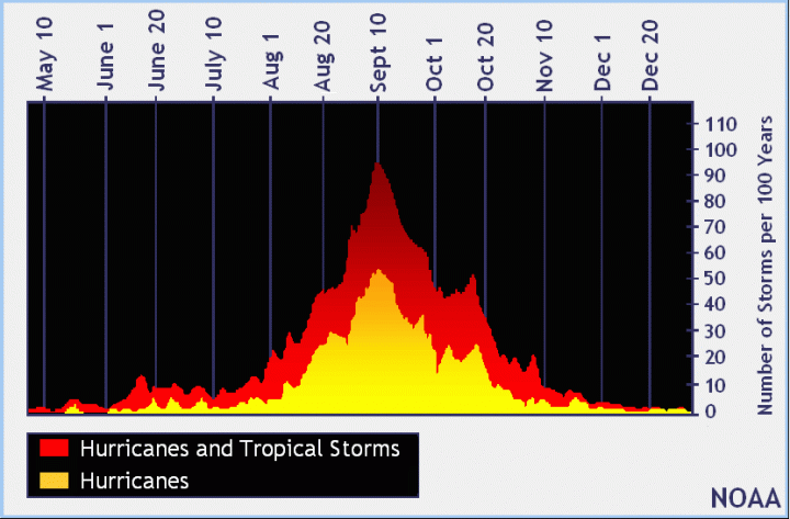
Normally June and July are fairly quiet, while early September, with the North Atlantic at its warmest, is usually quite stormy. The period of time from late August through mid-October tends to be playtime for hurricanes. Then the season usually fades during November.

Image: It’s September—party time for hurricanes.
Even within this broader pattern, there are busy periods and quiet times. Aside from the January Hurricane Alex (which was just plain weird), we saw a cluster of storms in late May/early June and the cluster that started in mid-August and continued into September. Late June and July were refreshingly boring.

Image: 2016 Atlantic Hurricane Season Source: Wikipedia and Browning Media
The Madden Julian Oscillation
So why does this happen? It’s because of a weather pattern called Madden Julian Oscillation (MJO). The MJO is an eastward moving “pulse” of clouds, rainfall, winds, and pressure that crosses our planet near the equator—and returns to its initial starting point in 30 to 60 days, on average.
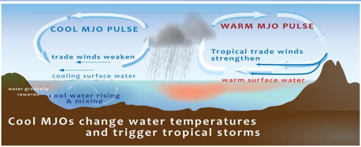
Let’s make this simpler. Think of the equator as a string and MJOs as beads sliding around the string, from west to east. Some are fairly quiet and the ocean below bakes under warm, sunny skies. Others are windier and the wind-tossed waters below are churned and cooled. When the cool waters hit the hot waters, cool windy air hits hot moist air, it creates a storm. Give the storm a nice twist and you can have a tropical storm that grows into a hurricane. As the cool MJO continues east, it hits more hot water and spits out another storm, sometimes three or four before it finishes crossing an ocean.

Image: The crash of hot and cold MJOs creates tropical rainfall which can grow into hurricanes.
Notice, universities and agencies around the world work together discovering these tropical troublemakers and trying to understand what they do. NOAA publishes these finding as a warning and weather people around the world can focus on the areas presenting the greatest risk. Sometimes they are wrong, but these warnings can save lives. Here you can see the warning of potential rain, storms and dry weather issued early September.
So next time you see a herd of hurricanes, you know a mischievous cool MJO passed by, scattering storms as it went.
See the 2016 Hurricane Forecast here.
Comments